


ni Lolet Abania | September 22, 2022
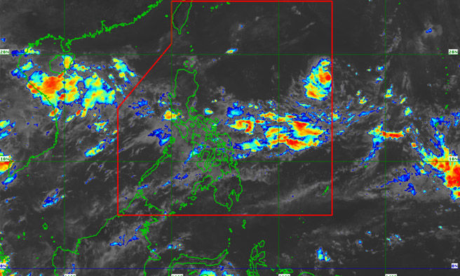
Isa nang tropical depression na pinangalanang Karding ang Low-Pressure Area (LPA) na namataan sa bahaging silangan ng Central Luzon, ayon sa PAGASA ngayong Huwebes.
Sa isang post sa Facebook, sinabi ng PAGASA na ang LPA ay umabot na sa tropical depression category bandang alas-8:00 ng umaga.
“At 8:00 a.m. today, the Low Pressure Area East of Central Luzon developed into Tropical Depression #KardingPH. Tropical Cyclone Bulletins will be issued starting at 11:00 a.m. today,” pahayag ng PAGASA.
Base sa 5AM weather forecast ng PAGASA, ang namataang LPA ay natagpuan sa layong 1,265 kilometro silangan ng Central Luzon ng alas-3:00 ng umaga.
Ayon din sa state weather bureau, ang Southwest Monsoon o Habagat ay makakaapekto naman sa western sections ng Central at Southern Luzon.
Makararanas naman dahil sa Habagat at localized thunderstorms ang buong Visayas, Palawan, kabilang na ang Kalayaan Islands, at Occidental Mindoro ng bahagyang maulap hanggang sa maulap na papawirin na may isolated rain showers at thunderstorms.
“Light to moderate winds from the Southwest to West, and slight to moderate seas are expected over the Visayas, Palawan including Kalayaan Islands, and Occidental Mindoro,” ayon pa sa PAGASA.
Samantala, sa kanilang 5PM weather forecast, ayon sa PAGASA patuloy na lumalakas ang TD ‘Karding’ habang kumikilos ito patungong Philippine Sea at posibleng umabot sa severe tropical storm category bago pa ito mag-landfall. “Current track and intensity forecast shows that there is a high likelihood that Tropical Cyclone Wind Signals will be hoisted over Northern Luzon and some portions of Central Luzon,” sabi ng PAGASA.
“The highest possible wind signal that may be hoisted is TCWS #3. Localities situated in the eastern portions of Northern and Central Luzon may be placed under TCWS #1 as early as Friday evening or Saturday early morning,” dagdag nito.